
beautiful mountain hikes
Hagenerhütte
We start in Sportgastein and hike leisurely on the high plateau to the head of the valley. There begins the wonderful ascent, also known as the Römerweg, between waterfalls and chamois. With a little luck you can admire one of the few bearded vultures. Arrived at the top of the ridge, the alp awaits us with a fantastic panorama. After a refreshment, other peaks can be climbed from there and then the same way back to Sportgastein.
| Level of difficulty | |
| Total duration | 5 hours |
| Length | 10 km |
| Ascent | 860 Hm |
| Descent | 860 Hm |
| Refreshment stop | Hagener Hütte |
Niedersachsenhaus
From Sportgastein you go into the Siglitztal and climb along a gigantic waterfall up to the Niedersachsenhaus, which is located directly on the highest point of the Scharte. After a longer rest with food and drink you can descend to Sportgastein via the Bockhartseescharte and the Bockhartsee.
| Level of difficulty | |
| Total duration | 7 hours |
| Length | 15 km |
| Ascent | 880 Hm |
| Descent | 880 Hm |
| Refreshment stop | Niedersachsenhaus, Bockhartseehütte |
Übergang Korntauern
The tour starts in the Anlauftal, from where we walk 45 minutes flat in the forest to the entrance of the Römerübergang. Now follows a steep ascent through the mysterious mushroom forest and at higher altitudes the pine forest leads us to the Korntauern crossing.
Having reached the top of the pass, you have a fantastic view in all directions. Now you descend to the mountain station of the Ankogel cable car and take the cable car down to the Mallnitz valley.
| Level of difficulty | |
| Total duration | 6 hours |
| Length | 11 km |
| Ascent | 1280 Hm |
| Descent | 200 Hm |
| Refreshment stop | Hannover Haus |
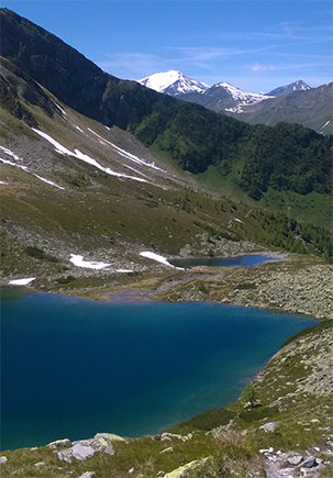
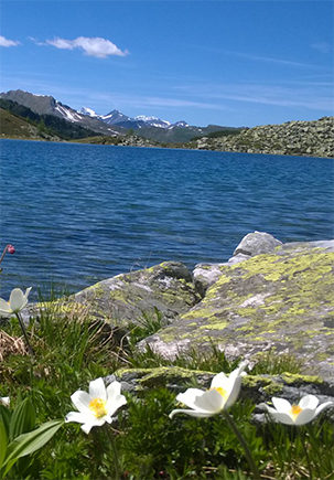
Palfnersee – Reedsee
A challenging hike with fantastic views of what is probably the most beautiful spot in the Gastein Valley – Reedsee! Starting from the hotel village Grüner Baum you hike in the direction of Prossau. The path, known for its steepness, leads us through mountain pine forests up to Reedsee. In the clear blue mountain lake the stone pine forest and the white mountain peaks of the Tauern chain are reflected.
The trail continues up to the Palfnerscharte, where you will be rewarded for the strenuous ascent by a fantastic view. Via the Palfnersee you reach the Graukogelbahn, which brings you down to the valley.
| Level of difficulty | |
| Total duration | 7 hours |
| Length | 11 km |
| Ascent | 1350 Hm |
| Descent | 370 Hm |
| Refreshment stop | Gipfelrestaurant Graukogel |
Schuhflicker – Paarseen
The Fulseck is the starting point of this beautiful alpine hike. Directly along the ridge ridge we follow the “path of the forces of nature” to the Arltörl. With a magnificent view of both the Grossarl Valley and the Gastein Valley, we hike towards the rock towers of the Schuhflicker.
Arriving at the summit, a very colorful alpine flora and a magical reflection of the summit in the Schuhflicker lake below await us.
Along the ridge we reach the enchanting Paarsee lakes, where we can enjoy a breathtaking view of the massive Hochkönig mountains. After a leisurely rest, the trail leads us across long meadow fields back to the valley.
| Level of difficulty | |
| Total duration | 8 hours |
| Length | 18 km |
| Ascent | 450 Hm |
| Descent | 1300 Hm |
| Refreshment stop | Steiner Hochalm, Paulbauernalm, Alpengasthof Hauserbauer |